Backpacking the International AT through Katahdin Woods & Waters National Monument
December 13, 2017
Posted in
By Stephen Brezinski
This past August, I had the pleasure of further exploring this new national monument, via the not so new International Appalachian Trail (IAT). The IAT begins at Mile 12 on the Katahdin Loop Road in the southern portion of KWWNM, just east of Katahdin Lake and Baxter State Park.
After the 3 ½-hour drive, our plans were to leave a car at the private Matagamon Wilderness Camps (MWC) at the north end of the hike. The camp owners arranged our hour-long ride back south to mile 12 of the Monument’s Loop Road for the beginning of the 30-mile trek. With all the driving, my hiking partner (trail name Respite) and I (Tommy’s Brother) got on the trail mid-afternoon for a leisurely 4-mile walk to Wassataquoik Lean-to.
Much of the trail system within the monument is on old logging roads, wide enough to often hike side by side. Though well marked, we needed to pay attention to the trail markings and maps, as it would be easy to turn down the wrong old tote road. In many places the wide old roads are grown in with thick shrubs. Trail markings consist of hundreds of blue and white metal IAT markers and blue surveyor’s tape tied onto tree limbs.
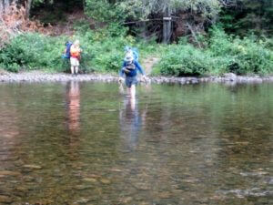 The first real challenge was fording the rocky Wassataquoik Stream, which is about 150 feet wide at the ford. The stream was knee deep and not too swift at this time; with a spring melt and runoff I expect it through the forest.
Day 2 was the most strenuous with climbs up and over Deasey Mtn. and Lunksoos Mtn. It was only eight miles to the next shelter but with the only significant elevation change of the entire walk. Good views are had east and west from these peaks. Cell phone service is generally bad in the monument so these peaks offered an opportunity to contact home. In this section of the trail, low shrubs and trees regularly blocked and masked the trail and the blue markers, which kept us on our toes checking map and compass and paying attention to our sense of direction. The lone day hikers we encountered in our four days told us that trail clearing and building was temporarily on hold while the National Park Service and International AT Club negotiated trail maintenance.
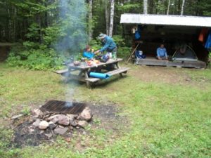 On Day 3 we had a 10-mile easy walk from Lunksoos Lean-to to Grand Pitch Lean-to, which is situated along the East Branch of the Penobscot River. Each of the lean-tos was similar to those on the AT, hold six persons, are relatively new and in good condition. There is also tenting space, picnic table, privy and fire ring.
Side trails along the East Branch of the Penobscot River lead to beautiful sights like Grand Pitch Falls, Haskell Rocks, Haskell Hut and Stair Falls. I love hiking in August in Maine; most all of the black flies and mosquitoes had passed on so there was little need for repellant and mosquito netting. The only night we slept under netting was at Grand Pitch Lean-to next to the river.
On Day 4, we hiked out to the car at MWC and enjoyed great meals, showers, and a campsite along the river.
Though we were in prime hiking time of the summer, we encountered only two other backpackers going the same direction and pace as us, and two day hikers on Lunksoos Mtn. The most recent entries in the lean-to logs were two weeks earlier. While we saw no moose or bear, I have never seen so much fresh moose and bear scat in any other area, so we know they were out there; I am sure they saw us. My hope is that in the future this new National Monument may take some of the excess tourist and hiking traffic from Baxter State Park and the ever-crowded AT.
This is a wonderful area and I hope to get back next summer. I understand that AMC is planning to arrange AMC hikes and backpacks to the KWWNM in the summer of 2018. Check the Maine IAT and the KWWNM websites for maps and trail info, and contact the staff at MWC for information on staying there and a ride to or from the trailhead.